The lesser known 200-year-old Buckingham Canal which was used for navigation once by the Britons is nothing today, but just a canal that carries sewage water within the limits of Chennai, largely due to the poor waste management and rampant encroachments that prevail in the city. The canal flows the entire longitudinal length of the city of Chennai in varying forms and uses. The width of the canal between the Cooum and the Adyar River has been reduced to less than 6 metres, which used to be almost 60 metres in the past.
Just on top of the canal runs Chennai’s Mass Rapid Transport System (MRTS), the stretch from Thiruvanmiyur to Central Station, and this has been one of the prime causes behind the reduction of its width. The canal that runs in the city is encroached by industries, government institutions and residents.
Alarmed by the condition of the salt water tidal canal, Prithvi Mahadevan of AgamSei, a social enterprise and Udhaya Rajan of WeBe Design Lab, an architecture firm are identifying the relevance of the canal in the present day context. Bhavani Prabhakar caught up with the researchers to find out more about their study of the canal.
What led you to choose Buckingham Canal as the focal point of your research?
Udhaya: We wanted to understand how the city evolved in the framework of its relation with its water bodies and began to study these post the December floods of 2015. We were keen to know the reason behind the massive flooding of the city which led us to looking at how water flows in and out of the city; this finally came down to the realisation that most of the water bodies are directly or indirectly connected to the canal. The waters from our storm water drains, rivers, lakes and other water bodies either drain into the canal or through the canal to the sea. The three major rivers in the city—Adyar, Cooum and Kosasthalaiyar are directly connected to the canal.
Thus, it became pretty clear that the canal, even though it was man-made, had a vital role in shaping the ecology of the city. Added to that, it passes the densely populated city which added a social dimension to the study. We decided to take the research forward after observing these parameters.
What are the objectives of the research?
Udhaya: The main objective of the research lies in understanding the nature of the canal with its evolution and what best can be done with it considering the present conditions. The characteristics of the canal have changed over the years, primarily because of the land use changes in the city and it is interesting to see how the canal adapts itself to the varied land use patterns. For instance, Ennore is an industrial area and the character and use of the canal is much different to the part in the core of the city, say Mylapore and Adyar. It gets accustomed to the residential locality when it flows through these regions.
Prithvi: This difference in character of the canal through different parts of the city was the most intriguing for us. It weaves interesting urban stories and has a great scope for multi-fold uses.
What have been your key findings so far?
Udhaya: We have completed our first phase in the research and working on the second phase. So far, we have looked at the current scenario and the nature of encroachments around the canal.
When we observe the part of the canal that flows between Ennore creek and Central railway station, we can see that the canal is located in an industrial area and the canal water is found with high viscosity since the industrial effluents and sewage remains are being let out without proper treatment.
Moving further, from Central railway station to Thiruvanmiyur, the locality has developed into a residential area that includes slum settlements and government institutions such as the PWD buildings. The MRTS stations in this stretch lie just above the canal meandering along its curves which in turn gives rise to conflict with its large residual spaces under the bridge and underused colossal stations that are rarely put to use, completely obstructing the canal.
The rest of the canal that runs beyond Thiruvanmiyur till Muttukadu is still pristine and ecologically sensitive, though giving in to urbanisation slowly.
Prithvi: Another major observation has been that the rivers are generally perpendicular to the sea so that it drains the water into the sea, but the canal runs parallel to the sea and cuts the whole city longitudinally. Due to this there is not much slope in the entire range of the canal having no water. Thus, the floodgates were used by the Britons to retain the water which used to enter the canal during the high tides for navigation. Since the floodgates are dysfunctional and desecrated today, it does not serve the purpose of retaining the water. With this in mind, we decided to research how the canal can be used in the current scenario.
Moreover, the government has proposed to make Buckingham Canal navigable again which may not feasible owing to the growing urbanization around the canal. However, it can be made navigable for recreational purposes such as rowing etc.
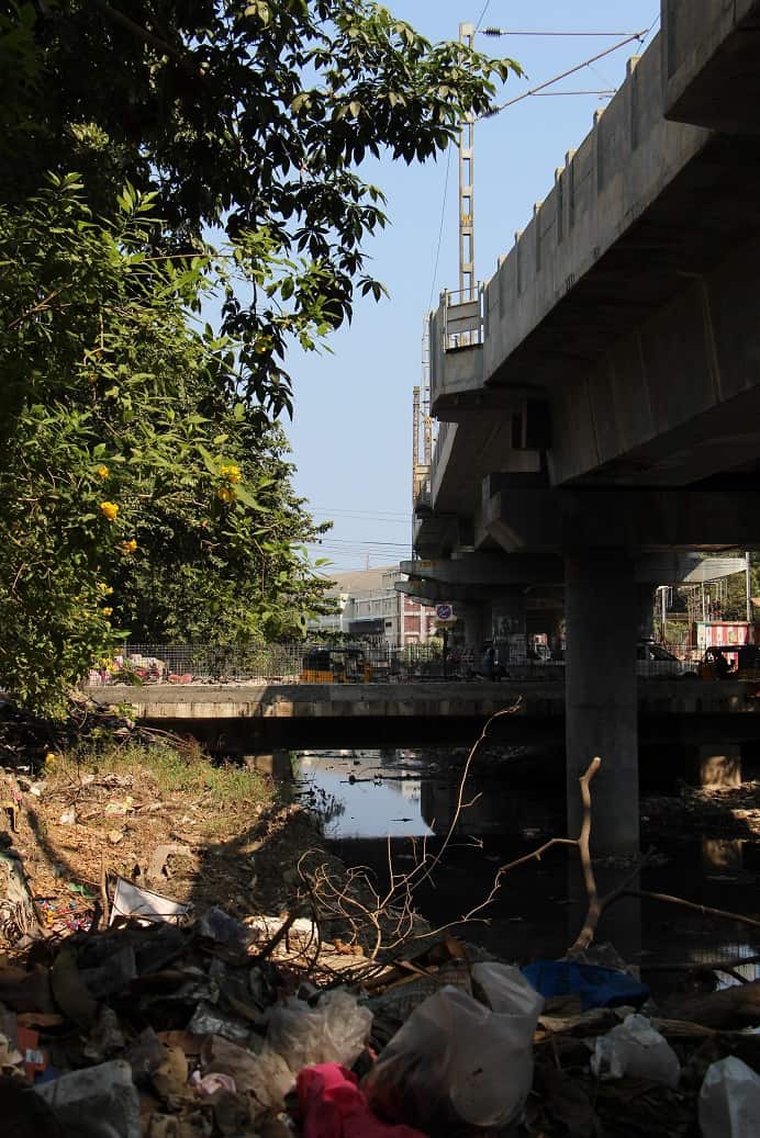
The Mass Rapid Transit System shadowing the canal carrying sewage, debris, and filth. Pic: Prithvi Mahadevan
How do you plan to sensitize people about these and how can citizens be a part of the move to restore the canal?
Prithvi: Right now we are working on unravelling the relevance of the canal in the present day context. So in a way, you can say we are sensitising ourselves. We believe that as we progress on our research and disseminate its findings, people will become aware of the issues and sensitise themselves.
Apart from this, the people of the city must be responsible in managing their own wastes, because it is ultimately due to poor waste management that the canal has been reduced to a garbage dump. The residents are also welcome to accompany us in our journey of finding the relevance of the canal and we would be happy to have them on board. For example, we recently organised a walk to observe the canal and see what is happening around it.
How do you plan to take the study forward? Do you have any suggestions based on what has already been observed so far?
Udhaya: The first phase was about the canal in general and we have just begun the second phase that specifically focuses on in-depth study of the canal that lies within the boundary of city, such as mapping the edge conditions of the canal, the type of activities underway around it, the composition of sewage that is being dumped, flow of water and quality of water.
The study will further reveal how such a waterbody flowing through a dense region should be treated. In addition, we are evaluating if a recreational spine can be created around the canal inside the city as we have only two major beaches in Chennai as recreational spaces.
But will a recreational makeover not affect the ecology and the original relationship of the canal to its surroundings?
Udhaya: The ecology of the canal has been much destroyed by incessant urbanisation with encroachments, with sewage and garbage strewn over extensively at different points of the canal in the city. But it becomes imperative to understand this evolution.
Firstly, the city was not as congested earlier as it is now, which directly impacts its interaction with the canal. As the city became denser, the canal came to be increasingly used as the city’s backyard dumping ground and was incessantly encroached.
Secondly, in earlier times, there were farming lands surrounding the canal and the water was directly used for the same; however, now we do not get water directly for our domestic needs from this waterbody which in turn reduces the connect with waterbody. Once we stop the direct interaction we cease to take care of the resource.
Thirdly, it was constructed in the first place to navigate goods and the canal got accustomed to the ecosystem later on. So, creating a recreational zone around it will not have any great impact on the ecology. In fact it will improve the current status of the canal which is a good thing and moreover, it will provide an urban relief too.
Cooum is not touched by Buckingham Canal. Adyar meets Buckhingam Canal behind Greenway’s Road. Only Puzhal Lake is released it meets at Manali Express Way at Satyamurthy Nsgsr. When Poondi it meets River Kosasthalaiyar. Canal is near there coming from Andhra.