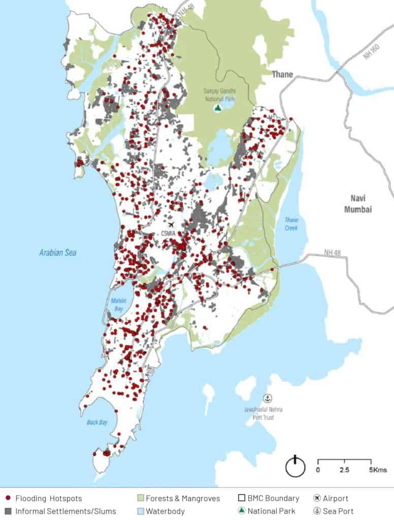
Mumbai has more than 100 flood-prone areas and around 300 landslide-prone areas vulnerable to the monsoons. According to the Vulnerability Assessment of the Mumbai Climate Action Plan (MCAP), 35.3% of the city’s population are at risk of being exposed to floods, since they are within 250 metres of the hotspots. Monsoon preparedness measures attempt to lower the risk and loss of life in case of heavy rains and potential hazards.
“The task of disaster management is to give relief,” says Prabhat Rahangdale, former deputy municipal commissioner (disaster management). “When disaster does strike, it is preemptive preparation that makes the most difference.”
That is why measures for monsoon preparedness begin in the previous year. Coordination meetings between the different stakeholders — the Brihanmumbai Municipal Corporation (BMC), ward officers, railways, police, MMRDA officials, etc — begin in December. “Each ward has a micro control room connected to the main headquarters, which is also connected to the police, fire brigade, navy, etc,” says Prabhat.
The India Meteorological Department (IMD), Mumbai, which tracks weather developments in the city, are a crucial component of this process. “We continuously monitor rainfall through our satellites, radars, the AWS, rain gauges and flows, and inform the BMC of alerts immediately,” said an official.
Flood-mapping for monsoon preparedness
There are over 100 chronic flooding spots in the city, of which 50 need evacuation,” said Mahesh. Earlier, the municipal commissioner Iqbal S Chahal told the media that there are 386 flood-prone areas in the city.
The process of identifying the areas is repetitive and manual; if an area is flagged for waterlogging repeatedly, it gets added to the list. In 2020, areas like Nair hospital, Worli BDD Chawl, Lamington Road, etc, were added to the list of vulnerable areas besides the chronic flooding spots of Hindmata, Nana Chowk, Gandhi Market, Parel, etc.
“We identify possible flood-prone spots, particularly in low-lying areas where flooding has been seen in the past,” says Kiran Dighavkar, additional municipal commissioner of the G North ward. “Where it’s possible, we carry out remedial measures and repair. But where it’s not, as in Dharavi where the houses are close to each other and the Mithi river, we install dewatering pumps.”
Dewatering pumps, manually operated, flush out the collected rainwater to a stormwater drain. In Kiran’s ward, eleven dewatering pumps – ten in Dharavi and one at Matunga station – have been installed for monsoon preparedness.
In total, 477 dewatering pumps have been deployed across the city. Six pumping stations and an additional six mini pumping stations, with differing capacities, will discharge the excess rainwater into the sea. Desilting the four rivers in Mumbai and their nullahs also plays an important role here.
“Flood hotspots include roughly the last three years (2018-2020) of geolocated coordinates capturing the complaints by the residents and observations made on site by the ward officers,” says the Vulnerability Assessment of the MCAP.
Read more: This monsoon, a disaster management app will help you stay prepared
Landslide preparedness
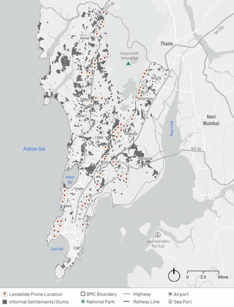
Landslides have emerged as another grave threat during heavy rains in Mumbai, especially after they caused the deaths of 29 people last year.
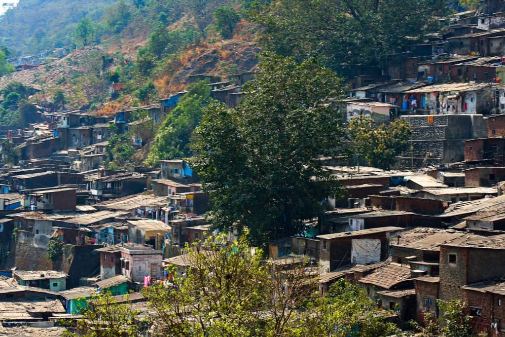
The BMC has identified 291 landslide-prone spots in the city, most falling in the eastern suburbs. “We superimposed the GIS-based data on our map of informal settlements, and found that 209 of them are in slums,” says Lubaina Rangwala, Associate Director at World Resources Institute (WRI) India.
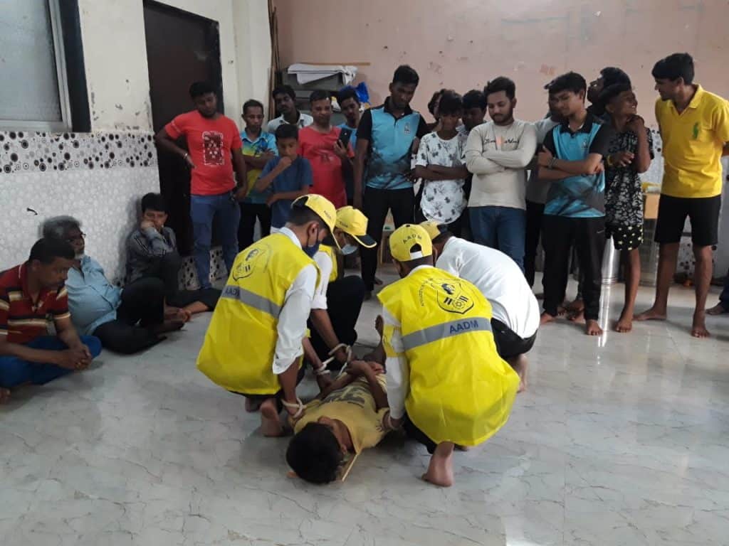
74 were found to be highly vulnerable, and of those 45 were identified as most at risk. The close-knit and structurally weak houses in hilly areas are the most at risk, more so because the terrain, lack of proper roads and heavy rains close off access to machinery and quick rescue. The BMC has employed two teams – 45 personnel each – of the National Disaster Response Force (NDRF) at Chembur, Bhandup, and Ghatkopar, identified as most at risk.
Long-term solutions to landslides are challenging, as some reports estimate up to 22,483 people living in these precarious locations are at risk. Lubaina mentions problems arise due to illegality and shortage in finances. Rehabilitation would entail uprooting residents from their spaces of work, education and sustenance, and is hard to do in the short term.
As an alternative, the disaster management department conducted landslide-preparedness training, starting in the 45 most vulnerable areas, in collaboration with WRI, YUVA, TISS and Aniruddha’s Academy Of Disaster Management. “A lot of the training sessions are being held at shelters, so the residents get familiar with them,” says Lubaina. Volunteers are instructed on precautions and emergency response methods, including CPR, casualty-carrying methods, first aid, etc.
“The training is also a space for the community to voice their concerns of their areas — cleaning the debris and sewage lines, and trimming trees — to the BMC officials that come,” Marina Joseph. associate director at Youth for Unity and Voluntary Action (YUVA).
Temporary shelters offer protection
Despite all the monsoon preparedness measures taken, if the risk of disaster — either a flood or landslide — arises, evacuating and temporarily relocating the most vulnerable residents becomes crucial.
“Mumbai is the most vulnerable when heavy rains coincide with high tides,” says Prabhat. “We monitor the levels of the rivers and the dams for overflow, and irrespective of rain, all agencies are alert.” Flood level sensors have been installed at the various rivers and lakes. These flood gauges alert the authorities about the dangerous swelling of the Mithi river and overflowing in dams, alerting authorities and calling for the evacuation of those on the banks.
For this, the BMC has designated five municipal schools in each of the 26 administrative wards, totalling over 130, to double up as temporary shelters. If these fall short, Mahesh assures that more schools can be used for the purpose.
“If we receive flood warnings and the water levels in the rivers, like the Mithi, are rising, we evacuate people in advance.
“If there is a warning of a flood-like situation in an area, like in Kranti Nagar, the respective area’s ward officer makes the decision to shift people to a temporary shelter,” says an official from the disaster management department who did not want to be identified.
Voices of the people
But the youth of the slum located at the foothills of the Sanjay Gandhi National Park tell a different story.
“We haven’t been told of any steps to take or shelters to go to. We aren’t even informed of flood warnings, we find out ourselves through social media,” says Sagar, a resident of Kranti Nagar. “We’re on our own.”
In the adjoining area of Appapada, separated by a nallah of the Poisar river, the story is similar. The BMC put up a warning poster, according to the residents, asking them to evacuate or stay at their own risk.
“While it differs on a case to case basis, in some places the BMC advises people to move out of danger zones,” says Marina. “But it isn’t enforced, and the people don’t have anywhere else to go. So most people continue living there.”