Over the past few years, Chennai has witnessed one natural disaster after another. Every time, officials and citizens themselves come up with knee jerk reactions and post mortem analysis of the underlying causes, but strangely, scant little is noted about the big picture of ecological damage in the city. Understanding the natural resources of Chennai and addressing their degradation in a sustained, systematic way is critical if the city wishes to avoid a Doomsday scenario in the future.
In an earlier article, we had discussed the rich heritage and long history of Chennai. Since 1639, Madras has expanded vastly in area and population.
At inception, the fort was 7.7 sq.km in area and by an estimate around 1650, its population was 15,000. Between 1901 to 2011 Chennai City grew in area from 75 sq.km to 174 sq.km and its population from 5 lakh to 46.4 lakh. Greater Chennai now covers 436 sq.km and its population, 86.5 lakh. Population density has increased from 6.8 thousand per sq.km in 1901 to 26.6 thousand in 2011.
Not surprisingly, both the increase in absolute population and the density have put a heavy strain on the natural resources of our city — the heritage that Nature endowed the city with.
Understanding Chennai’s ecosystem
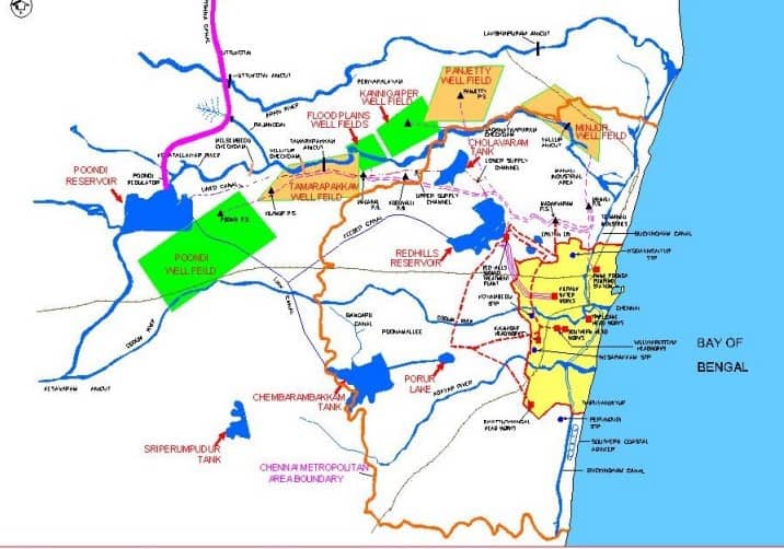
Water Source Surface and Sub Surface for Chennai Metropolitan Region
Source: http://jnnurmmis.nic.in/toolkit/CDP_CHENNAI.PDF
The natural ecosystem of Chennai comprises three rivers, five wetlands and six forest areas. The three rivers of Chennai are Kosathalaiyar, Cooum and Adyar. And then there is the Buckingham Canal, which though manmade, plays an equally important role in the water map of the city.
Among the wetlands Pallikaranai Marsh and Pulicat Lake are much better known than the other three, namely Kattupalli Island, Madhavaram & Manali Jheels, Adyar Estuary Creek. Among the forests, except Huzur Gardens , all – Vandalur, Guindy National Park, and the forests in IIT Madras, Madras Christian College and Theosophical Society, are commonly known.
When rivers lose their fish
It’s a well-known fact today that the rivers which cut across the city, Cooum and Adyar, have been reduced to being a part of the sewage drainage system of the city. A survey of fish species in Cooum found 49 species in 1949, which dwindled to 21 by 1979 and zero by the end of the last millennium. The river is dead.
That’s what happens when almost two-thirds of the total sewage generated is drained untreated into the river. The sheer lack of capacity to treat sewage is the issue. According to Metrowater, it supplies 830 million litres per day (MLD) of water to Chennai and roughly 80% of water supply turns into sewage. After adding private sources of water, the total water supply of Chennai is close to 2500 MLD.
The total capacity of the Sewage Treatment Plants of Metrowater is 550 MLD (Million Litres per Day), whereas the total sewage generated in the city is 1800 MLD. But Metrowater claims that it supplies 830 MLD and its capacity to treat is 550 MLD, so it has sufficient capacity.
Even if we assume that industrial and institutional sewage, which amounts to roughly 30% of the total sewage generated, should be largely treated by the industries or generators themselves, the Corporation cannot shrug off its responsibility for sewage generated by private domestic sources.
Buckingham Canal, once a waterway
The canal has an interesting history. The Duke of Buckingham ordered the construction of an 8-km channel linking Cooum and Adyar rivers for famine relief in 1876. This was later extended and linked to Cochrane and South Coast Canals forming what is now the Buckingham Canal (796 Km from Kakinada to Villupuram). It runs parallel to the coast, almost through the entire length of the city.
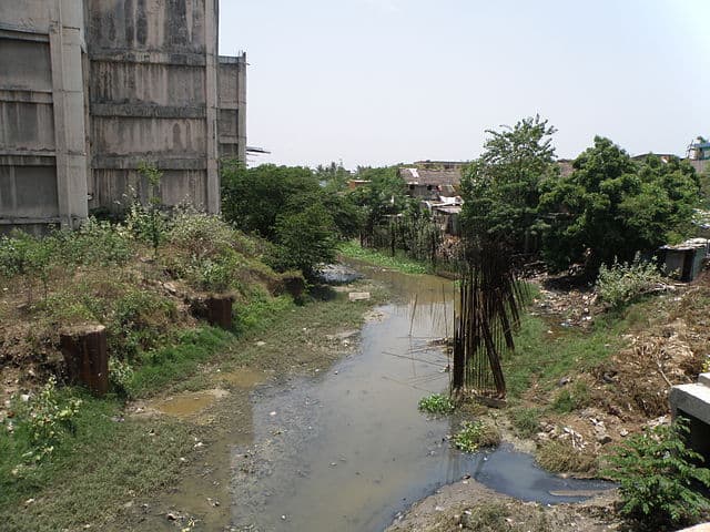
A stretch of the Buckingham Canal near Thiruvanmiyur.
Photo: Prateek Karandikar, Wikimedia
Buckingham Canal served as a cheap means of transportation until 1960, transporting rice, salt, fish, firewood, chunam shells and charcoal. It was also used by small passenger boats. Locks were provided at its junction with two rivers. The canal could control the tidal levels of the two rivers. The canal had the capacity to carry up to 5,600 cusecs when it was intact.
A well-maintained canal would have considerably mitigated the damage of the Chennai floods, but it is now badly polluted and a breeding ground for mosquitos. Insufficient freshwater flow in the canal aggravates the pollution. An article in The Hindu, points out that 60 percent of untreated sewage of the city is let into Buckingham Canal, which is also corroborated by analysis of samples at a 2010 Seminar on Waterways by Chennai Metropolitan Development Authority (CMDA). The late President and visionary Dr. Abdul Kalam, dreamt of National Water Ways and in our city here, we have lost the one we had.
Shrinking and silting wetlands
The Pallikaranai Marsh originally drained an area of 235 sq km, which came down to 50 sq km around 1970s. We have encroached it with an engineering college, an arts college, a hospital, a sewage treatment plant, solid waste disposal grounds, MRTS, NIOT buildings and a firewood wholesale market. Today, only 5.5 sq km of the marsh is left!
This marsh is one of the major groundwater recharging areas of our city, in addition to being a habitat for various birds. A study by the CMDA found that there was a potential to restore 30 sq km of the marshlands, but this, of course, was not followed up with any action.
Pulicat Lake is the second largest coastal lagoon in India with an area of 461 sq km. It receives freshwater from Arani and Kalangi rivers and some smaller streams. But while it measured 3.8 metres in depth at 1610, today it is only 0.8 metre. The lake has been silted at the rate of 1 metre per century and at the present rate, it will turn into a salt marsh in another 50 years.
Groundwater
Chennai is categorized as over-exploited in groundwater, and is among the top names in the list of “groundwater exploitation districts” according to the Public Works Department Survey in 2016. Over-exploitation indicates that the level of drawal is more than the rate of replenishment. Over-exploitation in shore areas carries with it the risk of salt water from the sea entering groundwater. Seawater intrusion is already happening in the Tiruvanmiyur area and along a 13-km stretch in Minjur.
The 2003 and 2004 droughts crippled water supply in Chennai and the piped supply system was shut almost for an year. It’s a reminder of the extent of groundwater dependence in the city.
Alarm bells from our neighbour, Bengaluru
After an elaborate study of the water woes of Bangalore in 2013, the former Additional Chief Secretary of Karnataka and Chairman of Centre for Policies and Practices, V Balasubramanian predicted that half of the city would have to be evacuated by 2023, due to water scarcity, contamination of water and diseases.
The prediction is also reflected in the reports of Karnataka State Departments, according to which, 52 per cent of the borewell water and 59 per cent of tap water in Bangalore is not potable and contain 8.4 per cent and 19 per cent E.Coli bacteria respectively. The increase in E.Coli bacteria is largely due to contamination of groundwater in half of the city with sewage water.
Between 2001 and 2011, the population of Bangalore grew by 65%. Fortunately Chennai has seen a steady growth and it has in fact slowed down in the recent decades. Will Chennai learn from Bangalore and ensure we don’t end up with a similar fate?
A wake-up call for Chennai?
Civilization developed along rivers. Collapse, a book delving into the causes of the collapse of historical civilizatios, found that three out of five factors were related to the environment. The ecosystem of our city too has gradually degraded over the years to a point where it has now reached alarming levels.
The damage to the ecosystem has been largely due to misgovernance and feeble civic engagement by its citizens. A city that can’t preserve its natural heritage can hardly hope to preserve its man-made heritage. If we focus on sewage water management, prevention of encroachment and maintenance of our water resources, we can perhaps still reverse the damage before it is too late.
Time to relocate Administration & Governance infrastructure further inland, west of Sriperambadur.
It’s time to act forgetting vote bank politics in the removal of encroachments along the waterways, backwaters and rivers.
Chennai has a system of minor inter-basin water transfer system where surplus from other season river basins is transferred to Chembambakam lake.
Redhills reservoir and the water works along Chembambakam serves major potable water needs of Chennai and its always kept full till the month of march.
Overflow of excess water from Chembambakam (last reservoir in the chain) contributed partly to the current flooding in Chennai.
Now the question arises,
(1) If we cannot plan minor inter basis water transfer system & infrastructure and anticipate its risks, should we go for large inter baisn water transfer projects?
(2) Do we have the capability / professional willingness & patience to do a proper job? If not why the hell we are rushing in the case of SMARTCITY Challenge.
(3)Do we have the maturity to undertake detailed environmental due-diligence and ability to balance politics & techno-commercial pull/push?